Sunday, May 1, 2011

Mom's visit to NZ

I always love when my mum comes to visit.  The first reason, of course, is that I love her and always miss her terribly when I’ve been away from the States for a long time.  The second (and far less important) reason is that it usually means that in exchange for planning her vacation and taking time off work, I get to go on holiday for free.  We both like to fit as much as possible into every holiday, and we certainly managed to do that this time.

My least favourite part of my mum’s visit was the drive to pick her up.  I had worked a full day at school, and in doing so had sentenced myself to a solo 6 hour drive in the dark.  Driving in New Zealand is much more intense than the expressways of America, so by the time I got to Auckland I was exhausted and sick of being behind the wheel.  Of course, the next morning the stress and headaches of the night before were confined to a bad memory, and my adventure with my mum began. 
The Auckland skyline,
under the Harbour Bridge

We spent the morning checking out Auckland.  First we took a boat tour through Auckland harbor, which was a really nice way to see the city.  Then we had lunch from the top of Auckland’s most recognizable landmark: the Sky Tower.  Auckland is a really nice city, and although we both agreed we could easily spend my mom’s entire two weeks there, we decided to head to the Coromandel Peninsula instead. 


Mom took this photo from our first camping spot, pre tsunami warning

Winding along the west coast of the Coromandel is the incredibly scenic Highway 25.  The weather was fantastic the entire day, and after a lovely drive we found a great place to make dinner and spend the night overlooking the sea.  Mom had been travelling for about 30 hours, so after having a couple glasses of wine with dinner we settled in for mum’s first night in the van.  Just as we were falling to sleep we got a call from Tom, telling us there had been an 8.9 earthquake and giant tsunami in Japan, and a tsunami warning had been issued for most of the Pacific.  At that point, we were half way up a cliff, and in hindsight would have been safe where we were, but we decided it was better to be safe than sorry.  We drove around for quite awhile in the dark, unsure of where we were going or where would be safe.  When we saw the signs for a “scenic lookout” we figured that would be our best bet.  We couldn’t find a perfectly flat parking space, but at least we knew we were safe from a tsunami.  At 3:30 a.m. we got a voicemail from Aunt Jeanne on Beaver Island, calling because she “just wanted to let you guys know there’s a tsunami headed your way.”  It was nice to know that, even from half a world away, the Wojan family is always looking out for us.
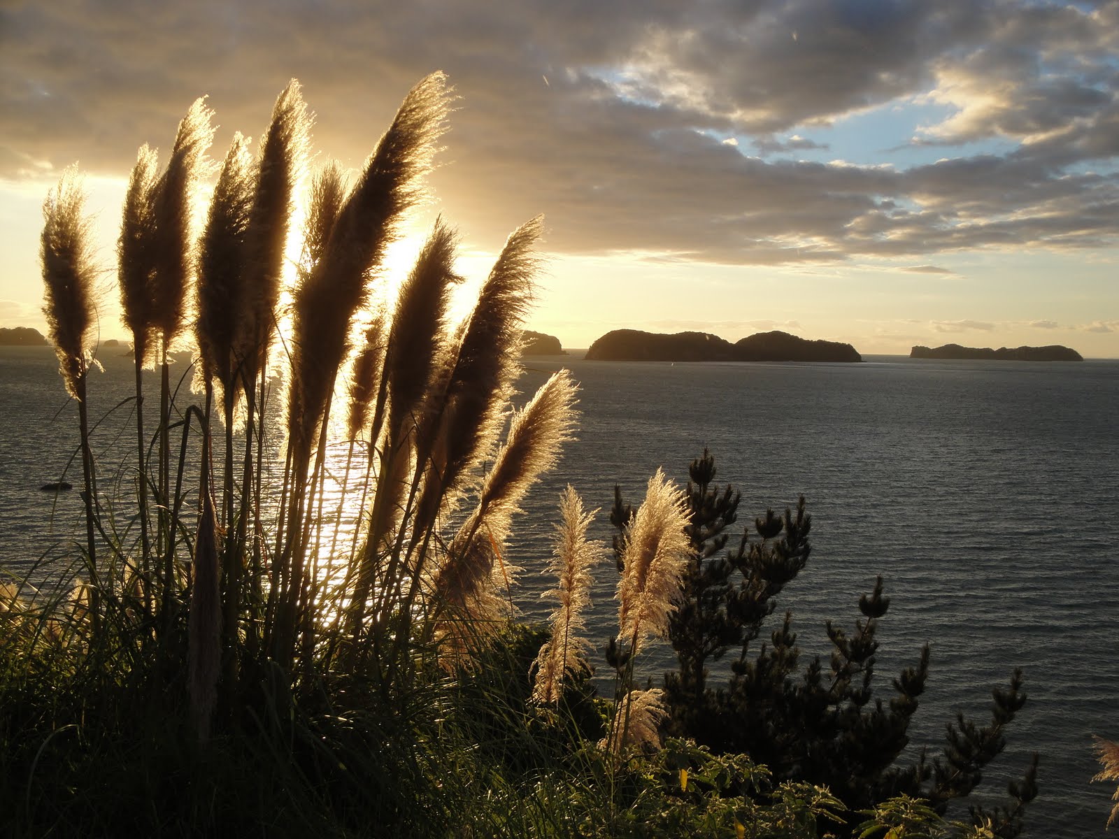
We woke up to this view from the very tsunami-safe scenic lookout

The next morning we were a bit hesitant to leave the scenic lookout, but even more hesitant to lose an entire day of our vacation, so we ventured on to Matarangi.  We stopped by an estuary, where there was a good sized hill between us and the sea, and made toast and tea.  We got to chatting with some locals who had been watching the water levels in the estuary.  In contrast to a typical day, where the tide comes in and out twice per day, they had already seen the water levels rise and fall four times that morning.  The water levels generally rise and fall quite slowly.  So slowly, in fact, that it’s quite hard to see.  That morning, we saw two surges that were quite dramatic.  It was easy to see the water levels rising rapidly.  Buoys that normally sit calmly on the water to aid boaters in docking were almost fully submerged in the rushing water.  It was quite cool to be able to watch a tsunami from somewhere we felt safe, and to have the added input of some locals who had grown up on the estuary and were shocked by the surges.

New Chums Beach
When we were confident that the tsunami had come and gone, and the beaches were safe, we made our way to New Chums Beach.  It requires half an hour walk through a river, over some rocks, then through a narrow path that eventually opens up to a spectacular beach with golden sand and turquoise water.  It’s been voted one of the top 10 beaches in the world, and although I haven’t seen all the beaches in the world, I’m certainly not surprised.


Mom and Quinten, on our fantastic
tour of the Cathedral Cove area

After some nice food and wine, a lovely sunset, and a much more comfortable night in the van, we headed towards Cathedral Cove.  It was raining that morning, but it cleared up just in time for an amazing boat ride.  We had a really great guide called Quinten who took us to the highlights of the coast, pointing out the volcanic features, islands, coves, beaches and even a natural blow hole.


Mum managed to capture the
sticky lines suspended
by the glowworms
From the Coromandel we headed toward the Waitomo Caves.  The most unique feature of the Waitomo Caves is the glowworms that thrive there.  They only exist in New Zealand and a small portion of Australia, and they’re breathtaking.  It turns out the part that glows is actually the bioluminescent poo of larvae.  They dangle lines from the roof of the cave with sticky bits of goo on them.  When flies and other insects are attracted to the glowing poo, they get stuck in the lines, which the larvae then pull up like a fishing line and eat.  Looking up at them from the floor of a dark cave it’s easy to forget all the science of bioluminescence.  It feels like you’re looking up at a sky filled with bright stars, and it takes your breath away.


Mom, a starfish, and Mt.
Taranaki in the background
Next on the itinerary was a return to New Plymouth.  It was great showing her where we live because she helped me to appreciate New Plymouth even more.  I would take her to a beach or a park that we had been to numerous times, and her enthusiasm was contagious.  We also got to show her the greater Taranaki area.  The mountain was hidden behind cloud for a majority of her visit, but she did get occasional glimpses of it.  Tom searched through the rocks and found lots of critters like star fish, kina, shrimp, crabs, brittle stars and sucker fish.  We met up with John and Angela for some evening fishing.  Luckily, we brought a chicken as back up, because we didn’t end up catching anything, but we did get a stunning sunset.


After the full tour of Taranaki, we set off in Mitzy yet again.  This time, we headed toward Rotorua.  In Rotorua, the earth—quite literally—farts.  Some of the world’s youngest volcanic formations surround Rotorua and Taupo, and there are active geothermic hot spots all over the area where heated gas and sulfur escape the earth’s surface.

Not hugely impressive,
unless you're my mom, but I sure did
love the encouragement!
After a day in Rotorua we escaped the sulfur in exchange for the fresh sea air at Mt. Monganui.  We had to spend an entire evening reading and playing cards in the van because the weather was horrible.  Fortunately, the next day we had sunshine.  We took advantage of the nice weather by climbing all the way to the summit of Mt. Monganui.  I also went surfing a couple of times.  I was frustrated because I didn’t think I was surfing very well, but there was one wave that I had stood on for quite a while, and when I looked up towards the shore, there was my mom, jumping and waving to let me know she had seen me.  It’s nice to know that even at 26 my mum is still my biggest fan and gets all excited over my very modest success.

We took the long and scenic way home.  After stopping at the impressive Wai Tapo geothermic park we drove around Lake Taupo.  It was beautiful.   That night we spent our last night in the van at a great campsite on the banks of the Wanganui river.  I have to admit, before she arrived I was worried she wouldn’t be able to spend two weeks camping in the van.  I thought we’d end up staying in hotels or bed and breakfasts, but she did really well in the van for the entire two weeks.   

On our way back to Taranaki we took the “Forgotten World Highway”.  It was incredibly remote.  A fair portion of it was gravel, and it took quite a while, but the scenery was fantastic, and we even had to stop to let a farmer get his sheep across the road, which was quite exciting for my mom.

Pukeko
Mom had an interesting observation that she mentioned a few times throughout her visit.  She noticed quite a lot of features that reminded her of something out of a Dr. Seuss book.  Sometimes it was trees, like Pongas.  Other times it was birds, like Pukekos, with their blue feathers and long, almost prehistoric looking legs.  Sometimes it was just the land features themselves: layers of cliffs with strange plants growing in all different directions.


After two sensational weeks of showing Mum around New Zealand, I was sad to see her go.  Tom and I dropped her off at the airport in New Plymouth, where she flew to Auckland, and then home to Michigan.  Every time she visits it flies by too quickly and I’m left a little homesick after her departure.  It helps to know that I’ll see her this August, and hopefully not too long after that she’ll be able to come visit me on yet another adventure.


Sunset in New Plymouth


Monday, April 18, 2011

Settled down, climbed a volcano

I have to admit I temporarily lost my motivation for writing this blog when Tom and I moved into our flat and started working.  Although it was nice to have a hot shower and be able to pee at night without needing a flashlight, it was also a bit disappointing to leave our travelling lifestyle behind.  We no longer have the excitement of not knowing where we’ll sleep tomorrow night, but our adventure has by no means come to an end.

We still enjoy fishing and surfing, we just have to fit it in to our work schedules.  Tom is working for a party hire company where he sets up marquees for weddings and events.  It’s not always full time, so he fills his other days working through and employment agency.  I am waitressing, tutoring and substitute/supply teaching, although it’s called “relief” teaching here.  I've just been offered a full time job as a long term relief teacher, which I will begin in June and keep until it’s time for me to leave New Zealand in August.  It feels like we only just arrived in New Zealand, but it's already time to figure out where we'll go from here.  It's a bit daunting and will be a lot of hard work, but we're hoping to come up with a good plan in the next few months.


We still spend a fair bit of time with Mitzy (the van), but we spend our nights in a small flat in the Westown area of New Plymouth.  We live in an apartment underneath the home of an elderly man named Alan.  He’s really nice, and keeps a lovely perennial garden.  There are always quite a few flowers in bloom, and every time one flower dies, another blooms to take its place.  The apartment itself is quite small but it’s close to the city centre and all our bills and furnishings are included in the reasonable rent.


John and Angela, above the clouds,
on our way to the top


Tom and I, looking a bit cheeky considering we're
standing in a crater that was once a river of lava,
and has collapsed 5 times
Shortly after we settled in New Plymouth we decided to climb Mount Taranaki.  Our friends John and Angela came, and we found out when we met up at the base of the mountain that it was John’s birthday.  When we set off we were all very enthusiastic and expecting it to be a fun day.  Although it ended up being one of the more rewarding things I’ve done in my life, and in hindsight I’m really glad I did it, I certainly wouldn’t call it “fun”.  It was one of the most physically challenging things I’ve done, and there were times I thought my legs were going to literally give out on me.  Fortunately, standing on solid ground above the clouds, and getting to the crater at the top, was well worth the effort.  It wasn't until we got home and I did a bit of research to find out how tall the mountain is (2,518 meters) that I found out that, in geological time, Mount Taranaki is due for an eruption sometime soon.


The "conquered" Mt Taranaki, taken the following evening from John and Angela's back garden

We hadn’t been settled in New Plymouth for long when my mum came to visit.  That, however, deserves a blog in itself…

Monday, February 7, 2011

West coast, back to The 'Naki

The largest known Kauri tree in the world

On our way down the west coast of the north island we passed through a couple of Kauri forests.  Kauri trees once covered this country, but because their wood is quite strong and easy to work with, they were logged extensively, nearly to the point of extinction.  Those that remain are now quite well protected, and the forests that they grow in are a real pleasure to drive through (even though, without our exhaust, we made quite a ruckus doing it!)

Gannets greeting each other


Our first stop on Auckland’s west coast was Muriwai.  It has lovely black sand beaches and one of the north island’s only gannet colonies.  The gannets were fun to watch; they’re graceful in the air, and highly skilled divers, but clumsy when landing; they kind of crash and stumble into their nests.  Then they greet their partners with a ritual of rubbing their beaks together (kind of like “Eskimo kisses”).  Although nice to look at, a colony of gannets is not at all nice to smell.  

standing near one of
many waterfalls 


We spent a night up in the hills near a big dam.  There was a 4km walk from the car park to the dam, and throughout the walk there were about 5 significant waterfalls.  Because there had been so much rain, the waterfalls were pumping, and even all the spaces in between them were dripping from every rock and cliff. 


From Muriwai we headed a bit further south to Bethells Beach.  It was yet another really nice beach, but the weather put a damper on things and we spent most of our time there in the van, hiding from the rain.


in front of the keyhole at high tide

Fortunately, we got lovely weather a bit further south at a place called Piha.  It ended up being one of our favourite places so far.  There was a great surf break, which a local told us had been good since before he started surfing there in the late 60’s, but the sand had shifted and the waves hadn’t been breaking very well for the past 10 to 15 years.  This is the first year it’s been really good again, so our timing couldn’t have been better.

Our friend Mr. Sea lion 


There is a really great series of headlands in Piha.  When we first arrived it was high tide and we swam out around one of them towards a more secluded bay.  On our way out Tom noticed something moving on the rocks, and we realized it was a sea lion sunning himself on the rocks.  We swam around and, at first, we were trying to sneak up to him for a closer look.  We eventually realized he wasn’t at all bothered by us, so we were able to get within about 6 feet of him.  Being so close to a wild animal, especially when he was making eye contact with us, was a bit nerve wracking, but they’re quite clumsy on land and there was plenty of rock to run on, so we figured we were safe.  It turns out there was no need to be nervous; he would look straight at us, then turn his head back toward the sun and continue to scratch himself. 

When we finally decided we had had enough of the sea lion we swam through what the locals refer to as “the keyhole”.  It’s a natural tunnel through the headland, shaped like its namesake. 


Tom, nearly finished with the climb out
through the keyhole.
That night, while I went for a surf, Tom went to scope out a fishing spot.  He had seen people fishing out on the rocks at the end of the headland, but couldn’t find the way out to where they were.  It was only when he mentioned it to a friendly local that we found out you have to climb through the keyhole to get to it.  The climb involves scaling the side of the keyhole, about 4 meters above the bottom, at low tide.  I have to admit I was a little nervous, falling from that height onto jagged rock and wet sand certainly would have ruined the evening, but there were plenty of rocks to hold on to, and Tom carried my fishing rod.   The mission to the rocks ended up being very much worth the trip, as we both caught our first ever gurnard.  They’re fascinating fish: bright pink bodies, fins that look more like wings, which are dark green and black and lined with a bright blue/green colour.  They also have funny whisker-like feelers on its underside that remind me of the legs on a lobster or crayfish.  Out of the water, they make a croaking noise, much like a frog.  When you hit them over the head the pink colour instantly changes to grey, then once it’s been dead a few minutes turns back to pink.  I was thrilled to have caught such a big one. (Especially because I was feeling the need to redeem myself.  Earlier that night I got all excited, thinking I had hooked a big fish, but had actually just gotten my hook stuck on a rock!  We fished ‘til after the sunset, and wouldn’t have made it back through the key hole if it wasn’t for the head torches (flashlights that wrap around our heads and therefore point to wherever we’re looking) that my mom sent for Christmas.
a small gurnard
We fried our gurnard up the next morning.  Even with all the fishing Tom’s done in his lifetime, he said it was the best fish he’s ever caught and cooked himself.


Next on the trip was a place Tom has been hearing about for years: Raglan.  It’s New Zealand’s most famous surf destination.  The conditions at Raglan make for pretty consistent waves that peel along the reefs in a way that makes for nice long rides.  It was a big crowded, and competition for waves meant that Tom only got one really good ride, but it was so long and so good it was worth it.  Since most of my surfing attempts still end in falling, I wasn’t ready for shallow waves breaking over rock.  I went to the sandy beach instead; the waves weren’t as good there, but I was able to practice getting to my feet, and when I fell it was on forgiving sand. 
One of the reef breaks at Raglan


looking through the
Mangapohue Land Bridge
When we had finished our time at Raglan, we headed toward Hamilton.  There were a few nice places to stop along the way.  Our first stop was at the spectacular Marokopa Falls.  From there we headed toward the PiriPiri caves.  It was quite a small cave, without much to explore, but still worth the stop.  About 20 minutes down the road we came across one of our favourite land forms from that area: the Mangapohue Natural Bridge.  Apparently, it used to be part of a very long cave, but throughout time had gradually caved in.  All that was left of the roof of the former cave was a small land bridge.   


When we got to Hamilton we stopped at the public gardens, which were really nice (and free) to walk through.  Afterward, we stopped in Waitomo, where there is an extensive range of underground caves, some of them filled with glowworms.  We were both quite keen to explore them, until we saw the price of admission.  (Maybe I’ll have Tom take me for my birthday.)  We got back on the road and before we knew it, we were back in Taranaki. 

It’s somewhat bittersweet to be back.  Bitter because it means our travelling around without a plan (or jobs) has come to an end.  Sweet because we’re back on familiar territory.  We know our way around, where to shop and find free internet.  Now it’s time to find a flat and get some proper jobs…

Thursday, January 27, 2011

Coromandel and Northland

Orokawa Falls
looking through Cathedral Cove

The Coromandel certainly lived up to its reputation.  All the drives were scenic, with frequent waterfalls and loads of punga trees.  The beaches were pristine with white sand and turquoise water.  We stopped for a scenic walk out to Cathedral Cove.  The walk was a bit of a mission, but the end result was well worth it; there is a beautiful walkway carved out of the headland  by the sea that connects two beaches.  Nearby, we went snorkeling in Gemstone Bay.  It’s in the middle of a marine reserve, so the fish and other critters were abundant.  If you swam slowly they would come and swim around you, almost as if they knew they were protected by law. 
Snapper

We spent an afternoon in Auckland.  After not really having been in a proper big city for months, we were a bit wary of the urban unknown.  It turned out to be a really lovely city.  It is busy and there is plenty to do and see, but it is also quite chilled out, especially for a capital city.  


From Auckland we headed north along the east coast.  We got some swell that was generated by a tropical cyclone, so we had a few good surf sessions over a couple of days, and went for yet another scenic hike at the Mangawhai Cliffs (be sure to check out all the photos by clicking on the link in the top right corner of the blog!)

We camped at a place called Sandy Bay for a night, and in the morning woke up to a second day of rain and wind.  We didn’t want to drive through what we knew was very scenic coastland on a day that the mist was so thick we couldn’t see past the next bend in the road.   I made the ironic mistake of asking, “What are we going to do today?”  just before we got in the van.  I got my answer a couple minutes later when Mitzy (that’s the nickname we’ve given our lovely Mitsubishi) wouldn’t start.

Thankfully, we had paid a bit extra along with our insurance for roadside assistance.  Of course, that would only be of any help if we could actually call the company to let them know we couldn’t start our van, and our mobile phone didn’t have any reception.  Luckily, there was a nice guy named Billy on his “lunch break” (which seemed to be a few hours long) who had stopped to check the surf.  He drove me up a series of hills until his phone had a bit of reception, and we called for assistance. There are much worse places than Sandy Bay to be broken down, so we really couldn’t complain, but it took about 4 hours for the tow truck to arrive.

We were nervous waiting for the mechanics to let us know what was wrong with the van.  We were afraid it would take a couple of days to get her fixed.  Mitzy’s not just our automobile, she’s also our home, so leaving her in the shop for a couple of days would have cost us a pretty penny in hotel fees.  Fortunately, it was just a buildup of carbon in the carburetor (Tom calls it a carboretta) and she was back on the road in about 2 hours. 


That evening we headed north and camped at the southern end of the Bay of Islands.  The next morning, we got up early and, based on the advice of the New Zealand Surf Guide (Tom’s bible for the year) we headed to a place called Elliott’s Bay.  It was already a pretty remote location, but in the interest of finding even better waves, we walked over a couple of headlands until we got to a secluded bay with nice waves.  It had started out as a cold morning, so I had set out with my jeans and a hoodie.  The treck was long and somewhat difficult, so by the time we were half way to our destination I was already sweating and regretting not having brought my bikini.  Luckily, we were in the middle of nowhere, with hardly anyone around for miles, so I spent the morning naked on the beach.  I went swimming and got a couple of good photos of Tom surfing.  Even by Tom’s high standards, it was an exceptional morning’s surf.  There was good swell, no wind, and it seemed as though he had the entire ocean to himself.  

Tom's wave of the day
We stopped that afternoon to use the public toilets in Kawakawa.  As funny as this may sound, they’re a bit of a tourist attraction because they were designed by a famous artist called Friedrich Hundertwasser.  

I know it's nothing epic, but that's me!
That night we camped near Taupo Bay and Tom got another good session of surfing in.  I also managed to stand up on a few waves.  Surfing is much harder than it looks.  I will say that what it lacks in ease it more than makes up for in quality of workout; if I don’t lose my bingo wings this year, I doubt I ever will.  


The following day we went a bit further north for more snorkeling in Maitai Bay, part of the Karikari peninsula.  Unlike Gemstone Bay in the Coromandel, we were not in a marine reserve, so there weren’t quite as many fish, but still plenty to look at, and crystal clear water made for great visibility.  We saw squid, a large sting ray, a few shoals of small fish, and in the deeper water some big and interesting fish.

From there we headed up into the region known as the “far north”.  The drive wasn’t as scenic as some of the others we’ve been on, but the northernmost part of the country was worth it.  It is home to New Zealand’s largest sand dunes, as well as the world’s purest silica sand deposits.  We rented a couple of body boards and slid down “Psycho Slope” a few times.  It wasn’t quite as big or steep as Sleeping Bear Sand Dunes in Michigan, but certainly the biggest and steepest dune I’ve even been down on a body board.  We would have loved to have spent hours going down the dune, but unfortunately we had to climb it each time and were exhausted after just an hour.  
Tom, 3/4 of the way to the top of "Psycho Slope"

Afterwards, we drove to the lighthouse at Cape Reinga.  It used to be a 10,000 watt bulb, powered by diesel and manned by a lighthouse keeper.  Now it's 50 watts, solar powered, and monitored by a computer in Wellington.  Tom’s favourite part of the scenery there was being able to see where the Tasman Sea meets the Pacific Ocean.  There were waves breaking far out at sea, and closer to the shore we could see them washing up on the beach in two different directions. 


That night we went for an evening surf and then waged a full on war with the mosquitoes.  We made sure the windows and doors were shut tight, but the little buggers kept finding their way in somehow.

We’ve been making our way down the west coast of the north island since then.  We preferred the eastern side of the island because here on the western side it’s a bit more difficult to access the sea.  When we did access the sea, it was on places like 90 Mile Beach (which is actually something like 80 km).  It’s golden sand for as far as the eye can see. There are plenty of places to rent quad bikes, go horseback riding, take 4x4 tours, etc., but there wasn’t a whole lot to do without spending money.  It doesn’t help that the weather has been pretty horrendous; it’s been raining and windy for 4 days straight.  It’s taken a bit of the romance out of living in a van.  There isn’t much to do inside the van besides read our books, it’s difficult to cook in the wind and rain, and the seal on the window above Tom’s clothes has a leak, so he’s quickly running out of clean dry t-shirts.

Our exhaust pipe broke off on a Saturday evening.  Nothing was open Sunday, so we’ve been driving around in an embarrassingly loud van for the last couple of days.  Fortunately we found a place that should have it repaired for us soon, and we’ll be able to get back to exploring the country without announcing our presence a kilometer before we actually arrive.

Monday, January 10, 2011

East Cape and Bay of Plenty

We stayed at Lucy and John’s place to look after their dogs and chickens for the first couple days of January.  We had a chocolate and a black lab, internet, tv, a trampoline and lots of toys.  They tried to pay us for our “trouble” but we had enjoyed it so much we couldn’t accept the money.  Instead, Lucy sent us on our way with loads of courgettes (zucchini), cucumber, plums, strawberries, a kumokumo, and a jar of her homemade picallily.  We didn’t have to stop at a supermarket for days.

We left Gisborne and headed north up highway 35 through the East Cape.  When we were first leaving town we commented on how spoiled we had become.  We knew the scenery around us was lovely, but noticed we were taking the hills and valleys of the Gisborne area for granted.  No more than 20 minutes later we came around a bend and, once again, had our breath taken away by a stunning view of the sea.  When we had a chance to take a detour off highway 35 to be closer to the sea, we decided to take it.  The map showed a road that went into Waipiro Bay, and another that would take us north to join back up with highway 35.  Not far from Waipiro Bay, the road we had been travelling on turned to gravel.  We were quite nervous that we had taken the wrong road, but hadn’t seen any other likely options, so we carried on hesitantly until we had to pull off the road to let a construction crew through.  They assured us that the little gravel road did indeed join up with “the main road” so we continued on, glad that we had taken the detour in the end; it was well worth the views of the sea.

We stopped for a surf near Te Araroa, not far from Hicks Bay, and then took a small road out to the end of the East Cape, to see the most easterly lighthouse in the world.  The road out to the lighthouse was spectacular.  To one side were steep cliffs.  The tops of the hills were covered in cloud, so we couldn’t quite make out how high they actually were.   The other side of the road fell straight into the sea.  It was one of our favorite roads in New Zealand, and considering all the places we’ve been, that’s really saying something.


The villages around the East Cape are small, and we found ourselves worried about running out of petrol.  After travelling for 2 hours through mountains without passing a single petrol station, we were relieved to see one in Raukokore, just on our way in to the Bay of Plenty. 

the view from Mount Maunganui
The Bay of Plenty is quite a lot different than the East Cape.  We certainly wouldn’t struggle for petrol here.  It’s the most urban of places we’ve been so far.  There are even roads with medians/central reservations, sometimes with three lanes on each side.  It’s also a bit more touristy, but manages to be quite charming at the same time.  Cities like Whakatane, Tauranga, and Mount Maunganui have more trendy bars and shops, but fortunately lack the flashing neon lights and loud slot machines of seaside towns in the UK.


The major crop in the Bay of Plenty is the Kiwi.  They don’t need picking until March, so we’ve decided not to stick around looking for work.  We’re headed to the Coromandel Peninsula next; it’s renowned for its amazing scenery and coastline...

Tuesday, January 4, 2011

New Year 2011 at Rhythm and Vines

early in the evening
the VIP tent


Rhythm and Vines was a huge success.  We worked a lot of hours, met some really great people, and had an absolutely brilliant New Years Eve.  The festival was a really good one.  In amongst the hills and grape vines were:
·         About 6 stages, (including one with a natural amphitheatre made by the hills around it)
·          food and drink vendors (where we got free staff meals but still managed to spend too much on drinks)
·         a water slide ($2, unless you go naked, then it’s free)
·         hammocks (a whole hillside full of them!)
·         a really lovely VIP tent (we impressed the boss, so we got in free)
·         about 25,000 other people
·         a wicked fireworks display at midnight


The main stage, just before midnight

the hill of hammocks


We managed to stay up and be amongst the first to see the light of 2011.  Someone told us Rhythm and Vines was ranked the 2nd best place in the world to be for New Years Eve.  Paris was supposed to be the first, but I’ve been to both and I prefer the hills of New Zealand’s east coast.

The east coast has been seriously lacking any swell.  I haven’t even had any little waves to practice on, and Tom certainly hasn’t seen a good wave since Boxing Day.  We should have asked Santa for some waves.
We’ve really enjoyed Gisborne, but we’re ready to move on and experience a bit more of the country.  I keep finding myself singing Willie Nelson.   When we get “on the road again” we’re going to take the long way around the East Cape and in a few days should be arriving in the Bay of Plenty.  Hopefully we’ll find more work when we get there, and loads of amazing scenery in the meantime.

Tuesday, December 28, 2010

A happy holiday, indeed!

Tom and I finally found work at the Rhythm and Vines festival in Gisborne.  It started ten years ago as a relatively small music festival in a vineyard and has been getting bigger and better ever since.  A few weeks ago we signed up to volunteer in exchange for admittance because we had heard it will be loads of fun, but knew there was no way we’d be able to afford the $200 tickets.  We got emails saying that there were enough volunteers, so they wouldn’t need us.  Thanks to Tom’s experience at See Tickets in Nottingham, we were able to score paid work instead.  So far we’ve been working 12 to 14 hour days, but we’ve been told things will slow down and we’ll be able to celebrate the New Year.  The live music the night of the 31st goes ‘til 8:00 a.m., so if we manage to stay up that late after a full day of work we’ll be some of the first to see the light of 2011.

Our Christmas Eve camping site

We worked Christmas Eve and Boxing Day, but managed to have a really lovely Christmas in between.  We drove back down to the Mahia Peninsula to celebrate, and camped on the sea, surrounded by Pohutukawa trees in bloom.  It was really strange to be wearing a bikini and loading on the sun screen instead of spending the day out in the snow or in a warm kitchen.  We went for a walk on the beach, then met up with our friends John and Angela from Taranaki.  The four of us went for a surf and then had some really nice food.  We had New Zealand mussels, sirloin steak with portabella mushrooms, nice salad, and ham from the pigs we helped feed a month ago.  After fishing and a small bonfire we sat around a picnic table with our lantern, drinking beer and wine and having a good laugh.  Boxing day we got up early, went for a quick surf, and got back to Gisborne in time for work.